The pristine swimming pools of Gran Canaria’s coastal resorts are a far cry from the island’s origins.
Exquisite bougainvillea fringes tranquil patios where holidaymakers have long breakfasts in the early morning warmth. Through the morning mist, the undulating peaks of mountains are just visible.
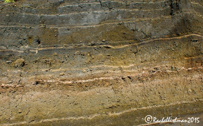
Today, these fertile mountain ranges stand as remnants of Gran Canaria’s violent, fiery eruption from the sea millions of years ago. A short drive inland not only provides postcard perfect vistas, but also a view into the past through the rock strata, volcanic craters and monoliths of the isle’s birth.
From my base in the southern resort of Las Palmas, famed for its tranquil microclimate and bronzed Norwegian tourists, I drove around the island to explore the bigger picture. Nature reserves where wildlife abounds, summit views across the ocean and volcanic craters awaited me.
La Caldera de Bandama; Northern Gran Canaria
Millions of years ago, molten lava spewed from the Caldera de Bandama (Bandama Crater) and ran into the ocean that lapped the newly formed mainland. In 2016, these old volcanic soils make for fertile farming and the valleys are full of healthy grape vines. Local restaurants like La Caldera, where I indulged in tea and cake on a magnificent balcony, make the most of fresh produce. The friendly female owner’s only regret was that her father passed away before seeing his vision of this extraordinary dining location realised.
Her story heightened my anticipation for the crater hike, which would take me for two hours around the ancient lip of the caldera, finishing in the tiny town of Santa Brigida. Its name is misleading; the crater was actually formed from lava meeting water forming a crater lake, which deviates from the traditional concept of a volcano. As I circled the rim, my thoughts turned from its formation to the beautiful flora that now thrived.
To one side my surroundings sloughed away to the blue seas of the Atlantic, while on the other, steep ravines dropped suddenly into the verdant pit of the caldera. It was difficult to imagine that a land of such rich green slopes and quaint terracotta houses could be created by such violence.

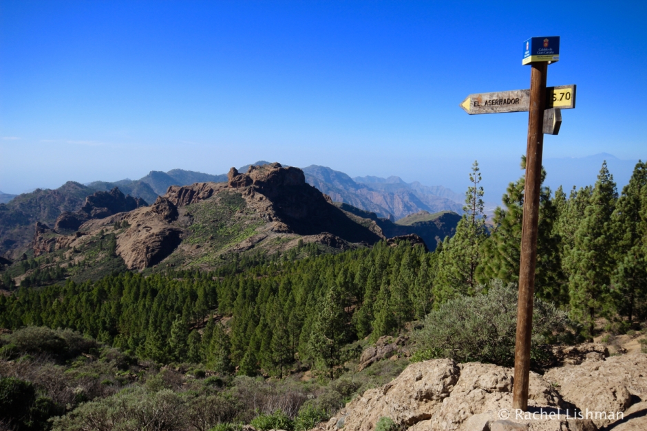
Roque Nublo; Central Gran Canaria
The road into the centre of the Island from Las Palmas rises suddenly and steeply, winding precariously along a cliff edge that hugs a beautiful valley of folded ravines. My steady and cautious two-hour drive finally threw me in front of Roque Nublo (or Rock in the Clouds). Roque Nublo is arguably the island’s biggest ode to its volcanic past. So much so, that the indigenous people worshipped this basalt monolith as a holy monument until relatively recently.
Despite being only the island’s second tallest peak after Pico de Las Nieves, I was stunned by the expansive views that the plateau offered. On the clear day that I visited, the highest summit of neighbouring volcanic masterpiece, Tenerife, emerged from the horizon.
As I took in the sun on a sheltered part of the basalt peak, I was reminded that Gran Canaria is one of seven notable islands that exploded from the Atlantic. For me, this rock in the clouds still had a mythical aura, despite it no longer being a site of reverence and sacrifice to the gods.

Dunas De Maspalomas; Southwest Gran Canaria

Only twenty minutes drive from my hotel there was a nature reserve where native birdlife sheltered and colossal towers of sand framed the shore. In fact, the Maspalomas dunes have been a nature reserve for well over one hundred years already. They can be visited easily from nearby roadways, however I chose to walk the two-hour trail from the lighthouse to do some bird spotting on route.
Formed from from the rise of the ocean floor during the last ice age, the dunes have gradually taken over an expansive proportion of the coastline of San Bartolomé de Tirajana province. The effort of climbing to their peaks is heavily rewarded by exceptional sea views and the silhouette of Maspalomas lighthouse on the horizon.
From the coastal dunes to the basalt pillars in Gran Canaria’s central provinces, the island’s volcanic past is still clearly visible and provides a healthy contrast to the mainstream resorts and bar strips that hug its ancient beaches.

Your posts always make my day fish. Keep them coming!
LikeLiked by 1 person
Thanks Rob! I’m back after a few months without posting 🙂
LikeLike
What an amazing post and absolutely stunning photos.
LikeLiked by 1 person
Thanks Miriam! Love your site and looking forward to following your travels 🙂
LikeLiked by 1 person
Thanks Rachel, likewise. 🙂
LikeLike
What an astounding collection of photos. So fascinating about the dunes rising from the ice age.
LikeLike
Thanks Sue! The sky was so blue there on the days I hiked that it was difficult to get a mediocre shot 😉 It’s a perfect island for walking…
LikeLiked by 1 person
Wow, what a spectacular landscape. Great photos, Rachel.
LikeLike
Thank you! Yes, it was so much more varied than I expected from a relatively small island. There were so many lovely walks that could easily keep you busy for months.
LikeLiked by 1 person